
Valparaiso ZIP Coverage at a Glance
Official USPS sources associate Valparaiso delivery with 46383, 46384, and 46385. Each number must still be checked against the exact address. Postal city names guide mail, not municipal rule. The table separates what the research verified from what still needs an address-level lookup.
| ZIP | Areas Covered | Post Office Association | Notes |
|---|---|---|---|
| 46383 | Core Valparaiso delivery addresses | Valparaiso delivery unit | May include addresses whose legal jurisdiction needs GIS review |
| 46384 | Alternative Valparaiso mailing contexts | Officially associated with Valparaiso | Delivery type and exact service area require address-by-address confirmation |
| 46385 | Outer and newer Valparaiso-area addresses | Valparaiso delivery association | Some postal addresses can lie outside corporate city limits |
The USPS Postal Bulletin maps all three to a Valparaiso delivery unit. The FAST label resource effective August 1, 2025 also links the Valparaiso label with 46366 and 46383 through 46385. That larger label grouping does not mean 46366 is a citywide Valparaiso ZIP. Use the exact street address rather than stretching the association beyond the official evidence.
Verify Valparaiso ZIP Codes with USPS
The USPS ZIP Code Lookup has three modes: By Address, By City and State, and Cities by ZIP. Address mode is the strongest choice. A company name is optional, the street line is required, and an apartment or suite may resolve multiple matches. Enter Valparaiso and Indiana, then save the standardized result.
| Field | Type | When Needed | Use |
|---|---|---|---|
| Lookup mode | Tab | Choose one | Address, city/state, or cities by ZIP |
| Company | Text | Optional | Business delivery name |
| Street Address | Text | Address mode | Standard street line |
| Apt/Suite/Other | Text | When applicable | Separates delivery points |
| City and State | Text and menu | Address mode | Valparaiso, IN |
| ZIP Code | Text | Depends on mode | Checks city association or address |
USPS standardizes delivery information. It does not confirm a person or business at that address. A match without a unit can still be incomplete. Once USPS resolves the line, carry the standard form into the parcel and jurisdiction checks.
The captured USPS FAST label list documents the source used to confirm the current postal association.
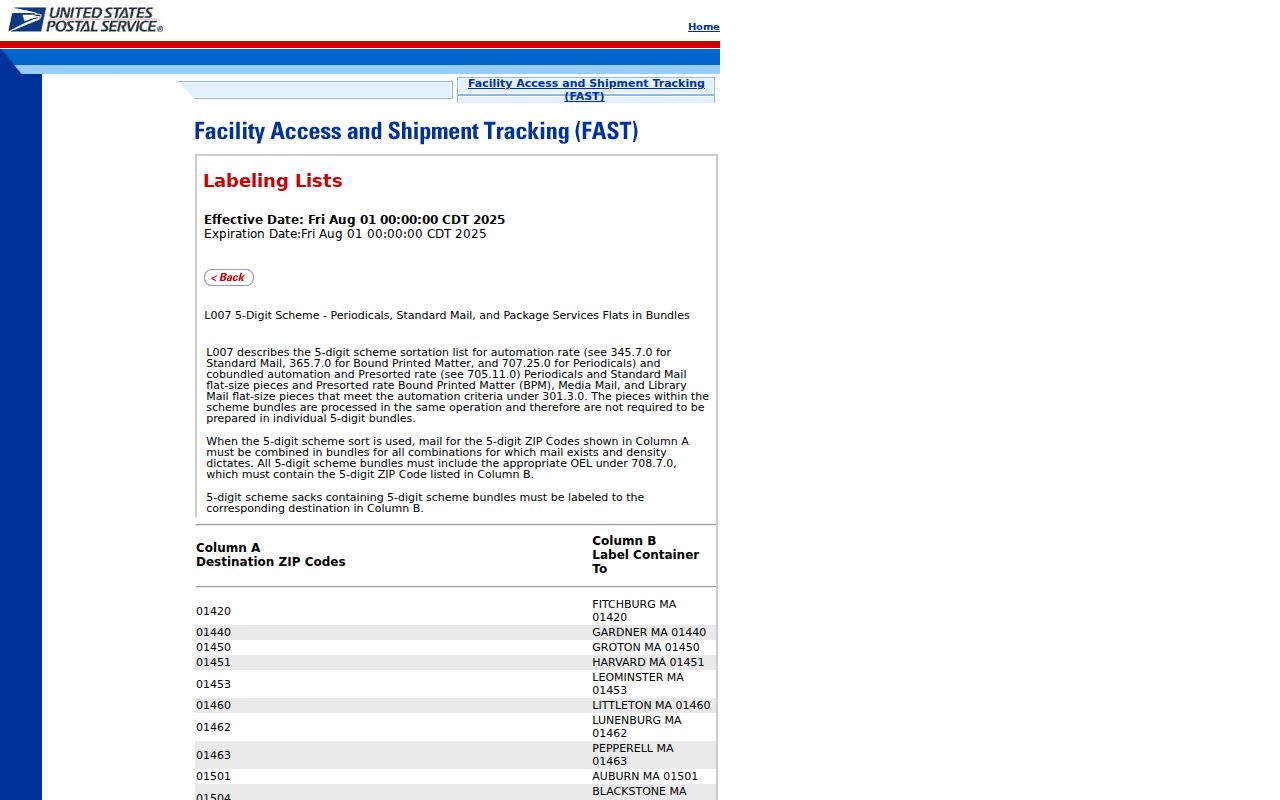
The label record supports the postal link, while the address tool supplies the precise ZIP needed for a parcel or person search.
Find Valparaiso Records by ZIP
No official local portal serves as a full ZIP-wide list of residents. The practical ZIP code directory workflow uses USPS as the postal check, Porter County property systems for the parcel, GIS for jurisdiction, and specialized state portals only where their own ZIP field is relevant.
- Run USPS By Address with the exact street line, unit, Valparaiso, and Indiana. Record the standardized line and returned postal code.
- Search the Porter County tax list or XSoft by address. Save parcel number, situs, owner role, tax district, and mailing address when shown.
- Open Porter County GIS and compare the parcel with municipal, township, county, road, and building layers. Confirm whether the postal and city boundaries agree.
- Use ZIP-capable business or professional-license portals only for their own public affiliations. A ZIP filter there does not reach everyone in the area.
- For old addresses, set the ZIP aside and bridge the street number through directories, plats, Sanborn maps, legal descriptions, and the present parcel.
Once a ZIP narrows the area to an exact street, the Valparaiso streets lookup handles the full address and parcel chain. It keeps street-level work separate from postal geography.
Valparaiso ZIP Search Gaps
Porter County XSoft has a rich owner, address, property-number, valuation, sale, building, district, neighborhood, year-built, area, and acreage search. Its inspected advanced form has no ZIP field. The Auditor tax list also lacks a ZIP control, though an address result can show city and ZIP. GIS searches parcels and map layers rather than a postal directory.
| Portal | ZIP Field | What It Can Find |
|---|---|---|
| XSoft Assessor | No visible ZIP filter | Owner, address, parcel, property details |
| Auditor tax list | No direct ZIP filter | Parcel, owner, tax year, address; result includes city/ZIP |
| Indiana PLA | Yes | Professional license records in a ZIP |
| SOS/INBiz | Yes | Business entities and public filing roles |
| USPS | Yes | Postal standardization and city association |
This asymmetry matters. PLA and SOS can narrow one specialized record type by ZIP; they cannot act as a Valparaiso people list. XSoft can find the parcel once an address is known, but it cannot produce a clean ZIP-wide export from the inspected form. The reliable route stays USPS → parcel → GIS → specialized record.
Note: Treat a ZIP-filtered license or entity result as an affiliation tied to that portal, not proof of a person's home.
Four Valparaiso Address Types
Records can attach several different addresses to one name or parcel. Knowing the type prevents false matches. A tax mailing line may be far from the building, and a Valparaiso postal city can cover land outside the corporate boundary.
- Situs address
- The physical location of a parcel, used by the Assessor, GIS, and permit records.
- Mailing address
- The destination for notices, which may belong to an owner, agent, entity, or post office box.
- Legal description
- The lot, block, subdivision, or metes-and-bounds text that remains useful when a street number changes.
- Postal city and ZIP
- The USPS delivery label, which is not the same as a municipal boundary.
Porter County tax districts add another layer. XSoft distinguishes Valparaiso in Center and Washington contexts, including district and MTE labels, from Center Township and Morgan-Valparaiso. Those district names are stronger evidence of tax jurisdiction than a ZIP alone. Check the parcel and map before assigning a record to city government.
Valparaiso ZIPs Versus City Limits
A 46385 street address can use Valparaiso as its postal city while the parcel lies beyond the corporate limit. The same caution applies whenever county facilities, outer subdivisions, or unincorporated land share the familiar city label. USPS decides delivery routing; the county GIS municipal layer and Assessor district identify local jurisdiction.
This mismatch changes which office holds a record. City permits and code files concern city jurisdiction, while Porter County parcel, deed, and court sources span the county. A ZIP code directory can narrow a search, but it cannot select the correct municipal custodian by itself. If USPS and city files disagree, ask USPS for standardization and the Assessor or GIS office for the parcel boundary record.
Boundary check. A Valparaiso postal line is not proof that the parcel sits inside Valparaiso city limits. Confirm the parcel in county GIS.
Valparaiso Postal Terms Explained
Postal terms describe mail routing, not the people who live in an area. Use them to refine an address and then move to the correct public record.
- ZIP Code
- A five-digit USPS routing code tied to delivery operations and postal city associations.
- ZIP+4
- The five-digit code plus four digits that narrow a delivery segment, building, or group of boxes.
- PO-box ZIP
- A code or use associated with post office boxes; research did not prove that all 46384 use is box-only.
- Unique ZIP
- A code assigned to one high-volume organization rather than a broad neighborhood.
- Carrier route
- A delivery path served by a postal carrier, not a legal city or parcel boundary.
The caution for 46384 is important. Official USPS lists associate it with Valparaiso, and local material uses it in alternate mailing contexts, but the inspected public lookup did not provide a current table proving one exclusive delivery type. Verify each address rather than labeling the whole ZIP as box-only.
Valparaiso Addresses Before ZIP Codes
The 1893 and 1902 Valparaiso directories show different street-number systems, and both predate modern ZIP codes. Current city code uses a 330-foot grid with Lincolnway as the east-west baseline and Washington Street as the north-south meridian. Yet no official conversion date or full old-to-new address table was found. Keep the literal old number in notes.
For an old resident, search the directory entry as printed. Use the street corner, subdivision, plat, Sanborn map, and Recorder legal description to locate the property. Then connect that geometry to the present parcel and add a modern ZIP in a separate field. Do not rewrite the old source as though the current postal code appeared in it.
The address issue is useful, not just inconvenient. A failed modern search can point to a number change, addition, annexation, condominium plat, or readdressing. Stable parcel numbers and legal descriptions bridge those shifts better than a ZIP.
ZIPs and Valparaiso Neighborhood Labels
Neighborhood names add local context but do not define ZIP coverage. A November 2025 city workshop listed 52 neighborhoods and associations, while the August 2026 Neighborhood Hub announcement described 54. The difference is best read as a date marker. Lists change as groups form, boundaries are refined, and civic profiles are updated.
The newer Valparaiso Neighborhood Hub announcement describes an address search and 54 profiles. That tool can classify a supplied address and point to civic contacts; it is not a private resident directory. Keep the source date with any neighborhood count and use the parcel map when a profile edge and ZIP seem to conflict.
City population figures also belong to city geography, not a three-ZIP total. Census QuickFacts reports 34,151 residents at the April 1, 2020 census and displays a July 1, 2025 estimate of 35,177. Neither figure should be divided among 46383, 46384, and 46385 without a published ZIP-level source.
Valparaiso ZIP Lookup Fallbacks
When a web result is unclear, use each custodian for its own fact. USPS resolves postal standardization. Porter County XSoft or the Auditor confirms the parcel and tax district. County GIS shows municipal and township lines. The Recorder supplies the deed and legal description, while a city office determines whether it has permit or code records for that site.
Bring the exact address, unit, parcel number, and conflicting ZIP results. For public records, a reasonably particular request under the Indiana Access to Public Records Act can ask for an existing address or parcel record. An office need not create a new ZIP-wide report that it does not maintain. Older questions may require the PCPLS Genealogy Center, State Library maps, city directories, or county historical scans.
Note: Save the date of each postal and parcel result because delivery labels, assessment data, neighborhood profiles, and city boundaries can change.